Drones
Whether documenting properties, assessing structures, supporting time-sensitive response efforts, or producing compelling visual media, our drone services offer a reliable and efficient aerial perspective that traditional methods cannot match. Every mission is conducted with attention to detail, regulatory compliance, and client objectives—ensuring dependable results across commercial, industrial, and creative applications.

Head House
Year
2025
Location
Texas State Capitol
Service
Fly Over
A cinematic fly over of the property, highlighting landscaping and the Capitol building

High Pointe
Year
2025
Location
Mansion, West Austin
Service
High Value Home Fly Through with Ammenity Focus
A beautiful property focused fly through of a high value home in West, Austin.


West Austin
Year
2026
Location
Colorado River - Four Points
Service
Aerial Nature Fly Over
An atmospheric fly over of lush greenery and the Colorado River at Four Points, West Austin


Recent Drone Work
Aerial Imagery for Real Estate
We provide professional drone imagery tailored specifically for MLS listings, delivering clear, elevated visuals that enhance property presentation.
We capture high‑quality drone and ground‑level imagery that elevates real estate marketing for short‑term rentals, Airbnb, and resort properties.
We create smooth, cinematic drone fly‑throughs that showcase a property’s layout, flow, and standout features in a dynamic, immersive way. Need video? We have your covered!
MLS Listing Photos
Marketing Packages
Cinematic Fly-Throughs


Aerial Imagery for Inspection
Great for acreage, construction sites, large lots, ranch properties, pre-development assessments, and solar farms. We provide insight from many different angles.
We provide detailed drone flights for insurance inspections, capturing clear aerial imagery that documents property conditions, damage, and claims‑related evidence with accuracy and efficiency.
We also conduct rapid drone assessments after storms and natural disasters, capturing clear aerial imagery that documents damage, hazards, and property conditions for faster, safer evaluations.
Land and Site Inspections
Insurance
Storm and Disaster Assessment


Aerial Media & Content Creation
Professional grade video from a completely new prospective. With views that give a new meaning to "Fly-through", we provide stunning video to meet the needs of your project.
We provide highly detailed aerial photography, capturing images from a variety of angles. From birds eye to close proximity, our drones are ready for vloggers, weddings, graduations, parties, or whatever else you want to remember with style.
We don't just capture video and photo, we ensure it is delivered with the professional editing that wins awards. We are here to deliver a completed product every time.
Fly-Through Videography
High Quality Photography
Professionally Polished Editing


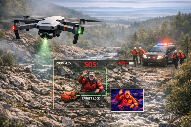
Public Safety and Emergency Response
We assist search and rescue operations with rapid aerial coverage, using drones to scan large areas, identify heat signatures, and locate missing persons faster and more safely.
We assist emergency and disaster response teams with rapid aerial assessments, providing real‑time imagery that reveals damage, hazards, and changing conditions.
We support incident monitoring with real‑time drone coverage, giving responders an elevated, continuous view of unfolding events. Our aerial perspective helps teams assess conditions, track movement, and make faster, safer operational decisions.
Search and Rescue
Emergency Response
Incident Monitoring
Unlike Our Competitors, We Have No Limit On How Many Photos You Can Get!


$75
Standard Rate
Ideal for quick inspections, photoshoots, standard videography, and other imagery without editting.
✓ We provide the drones
✓ High quality, 4K or higher imagery
✓ You prompt us and we handle the rest
✓ Fast turnaround
Delivery Time: 1–6 days
/hour
$1000
Package Plan
Full design experience for teams needing strategy
✓ We provide high quality drones
✓ Personal planner to help you plan the perfect shot
✓ Full service post-production editing service
✓ Perfect Shot guarantee
Delivery Time: <1–2 weeks
*A Planner will be assigned to your project to finalize package details
/package
Explore Pricing
Recent Addition To The SOS Fleet

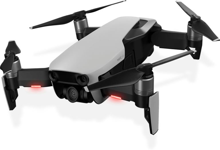
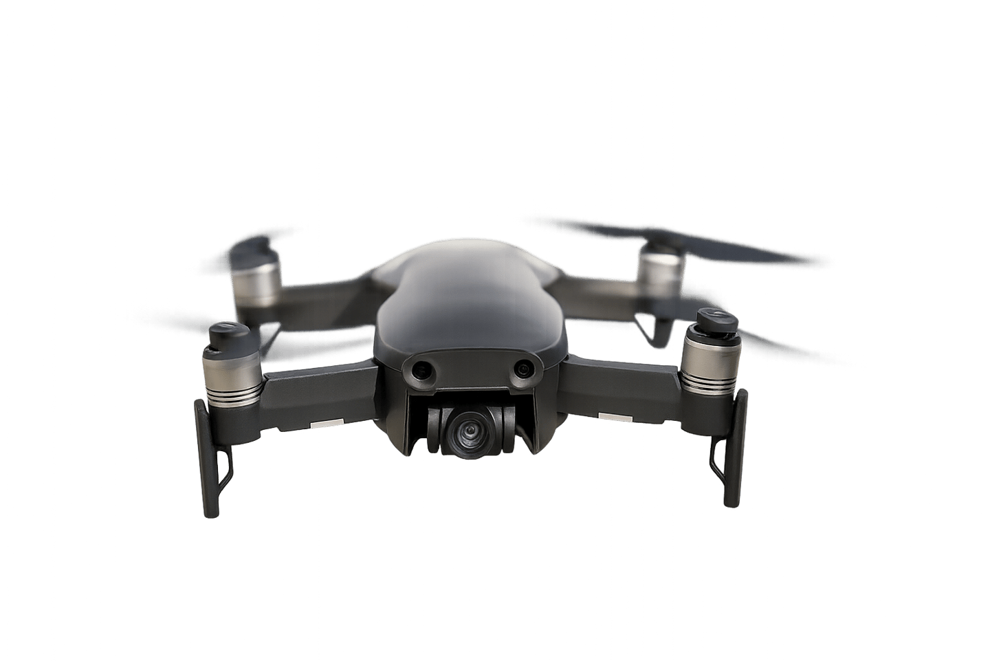
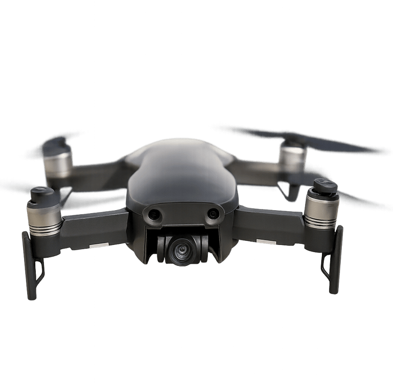
DJI Mavic Air
The DJI Mavic Air is a compact, high‑performance drone engineered for reliable field operations and detailed aerial imaging. Its lightweight folding design allows for rapid deployment in tight environments, while its advanced stabilization system delivers smooth, accurate footage even in challenging conditions. Equipped with a high‑resolution camera, intelligent flight modes, and robust obstacle avoidance, the Mavic Air is ideal for close‑range inspections, mapping, and documentation tasks where agility and precision matter.
For SOS TEXAS operations, the Mavic Air provides a dependable platform for property surveys, scene documentation, real‑estate imaging, and supplemental inspection work. Its portability, flight stability, and professional‑grade imaging make it a versatile asset in our drone fleet.
Speed x Inspection x Lite

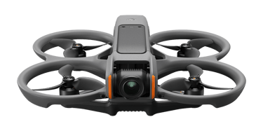
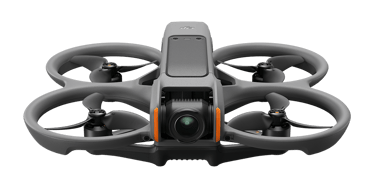
The DJI Avata 2 is a next‑generation FPV drone engineered for unmatched agility, precision, and close‑quarters maneuvering. Its compact, ducted‑prop design allows safe operation in tight, obstructed, or indoor environments where traditional drones cannot fly. With stabilized 4K video, low‑latency FPV control, and advanced obstacle sensing, the Avata 2 delivers smooth, dynamic footage while maintaining exceptional responsiveness and safety.
For SOS TEXAS operations, the Avata 2 excels in confined‑space assessments, structural inspections, and rapid‑response documentation, providing perspectives that larger platforms cannot safely achieve. Its durability and maneuverability make it ideal for navigating hallways, warehouses, construction interiors, and other restricted environments during investigative or safety missions.
The Avata 2 is also a powerful tool for real estate marketing and property showcases. Its FPV capabilities allow us to create cinematic interior fly‑throughs, guiding viewers smoothly from room to room and capturing the flow, layout, and character of a property in a way that standard aerial drones cannot replicate. Whether documenting luxury homes, Airbnbs, commercial spaces, or resort properties, the Avata 2 delivers immersive, high‑impact footage that elevates any listing.
DJI Avata 2
Indoor/Outdoor x Close Proximity